
Housing & Development
.

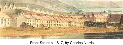
Temporarily, workers rowed to and from their homes in Milford, or lodged in Pembroke or nearby farms. The first four houses in Front Street were ready by
Michaelmas, 1814. These, it is said, were three homes for yard officials, and one public house. The town grew quickly. Early streets next to the Dockyard
were on Admiralty land. The town spread eastward on land which, like Front Street, belonged to the Bush estate of the Meyrick family.
The streets followed a grid pattern, similar to Milford's. Leasehold plots were let to individual householders. George Mason describes early dockyarders using
their evenings and spare time to build their own homes, often helping each other out -"these circumstances will account for the small houses and numerous
cottages". The Albion Square memorial, celebrating the town's centenary, pays tribute to the "the working classes who by their thrift and industry erected
during the century upward of 2000 houses."
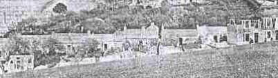
A picture of the main town before 1850 shows mostly small two storey houses. Today, single storey cottages remain in Charlton Place, and in High Street
Pennar and Waterloo still consist largely of single storey cottages
Michael McGarvie notes that, as early as 1819, speculators were also buying "land for as many as ten houses at a time". Bush Estate officials were sometimes
surprised to find rather more buildings than had been agreed, squeezed onto plots. "I can only account for it by supposing that each Lessee was allowed to alter
his plans as might best suit his fancy or convenience" mused Thomas Lewis, after whom Lewis Street is named.
In the 1840s, around 5,000 people dwelt in Pembroke Dock, and development of Pennar had begun. The Orielton estate, originally belonging to the Owen family,
owned land in this area.
Development in the main town was sometimes irregular. The development of south Dimond Street began in the 1840s, but more than a decade passed before
buildings replaced the thorn hedge on the north side.
Later nineteenth century house buyers, able to borrow from the Pembrokeshire Benefit Building Society, could afford more spacious properties such as those in
Church Street, Laws Street, Argyle Street and Hawkstone Road.
By 1871 Pembroke Dock's population had risen to 9,534, and by 1901 to 11,366.
Houses replace cottages: Belle Vue Terrace, c 1906
.
Some small early buildings were replaced - either individually or in rows - by larger dwellings. This happened to the unsalubrious "pig's parade" in west Bush Street,
where "a man could almost put his arm down the chimney and open the front door" and to the more attractive Belle Vue Terrace, where substantial houses replaced
"cottages nestling into the hillside surrounded by gardens of fruit trees".
Twentieth century developments include new RAF housing near the Dockyard and in Pennar. The street names Stranraer Row, Southampton Row and Sunderland
Avenue recall flying boat types operating from RAF Pembroke Dock.
Estate agents' advertisements from the late 1940s and early 1950s suggest features then considered noteworthy. Buyers may claim for war damage repairs. "Eletric
light and power plugs throughout" signify "an up to date modernised house" (some areas relied on gas domestic lighting until the 1950s). Closeness to a bus stop,
post office and church or chapel is a selling point, as is productivity of gardens, particularly in south-facing Pennar - food rationing was still in force. Before the
days of domestic central heating, garden coalsheds are desirable features. Water may be heated by coal fire or bathroom geyser.
Some blocks of new housing in older streets signify rebuilding after extensive World War II bomb damage. In the 1950s, new council estates extended Llanion and
Pennar. Later in the century, public housing replaced older buildings around King Street and in lower Pennar. Mr John Hogg's CD, Lost Pembroke Dock carefully
documents many of the other older buildings

1819 Ordnance Survey map
shows older settlements of Pennar, Llanion Farm is at
the foot of the Barrack Hill.
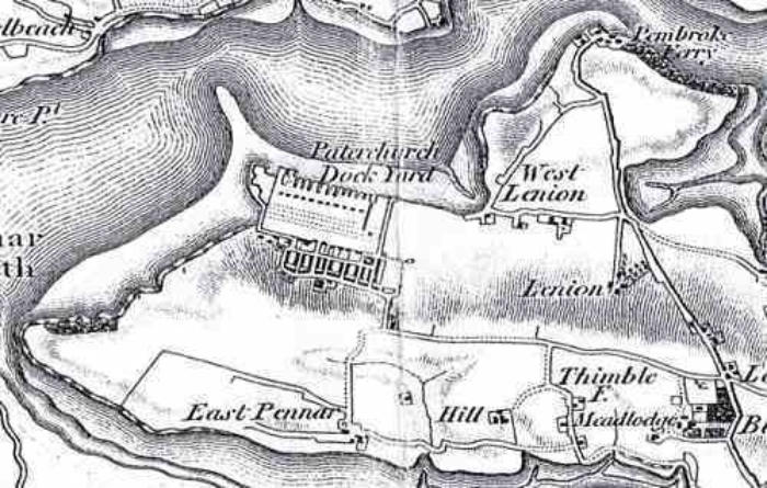
Note
: some maps and charts do not show every detail of Pembroke Dock at the dates given, but they offer a good general idea of the town's development.
Map is reproduced by courtesy of Pembrokeshire County Libraries.


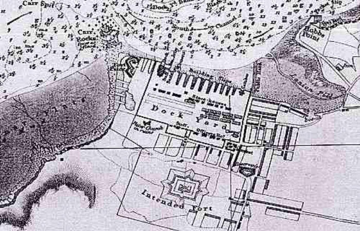
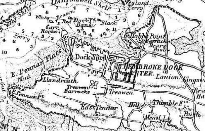
1830 Admiralty chart / map
Shows Hobbs Point packet slip (for Irish traffic), Fort Pater, public hard (landing place) at Front Street, Pater Church in ruins, market, and
reservoir (by Charlton Place). Note the size of an "intended fort", later the Defensible Barracks.

1831: Ordnance Survey map
Revised by Lieut. R. Dawson, R.E. to show local government boundaries. Llanreath begins to
develop.
Note
:

1841 tithe map.
Farm fields still predominate.

Note
: some maps and charts do not show every detail of Pembroke Dock at the dates given, but they offer a good general idea of the town's development.
Map is reproduced by courtesy of: Pembroke Dock Library.
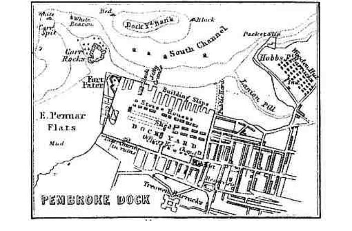
1865 (?) Fullarton's chart (i).
The Neyland ferry goes from Hobbs Point, Llanion hut camp is built, as is "Treowen Barracks"
(the Defensible).

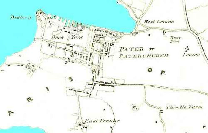
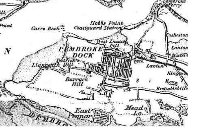
1865 (?) Fullarton's chart (ii).
Hobbs Point is still labelled "Packet Slip", the hut camp has appeared at Llanion, and Paterchurch is
now inside the Dockyard wall.

1892 Ordnance Survey map.
The main town and Pennar have expanded, and the railway station is established.

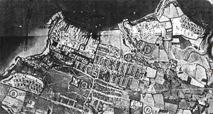
1940-1 German air photograph, for use by bomber crews.
Marked targets include Llanreath and Llanion oil tank depots, the Dockyard RAF station, and the
Defensible and Llanion Barracks.
Some of the small craft moored by the Dockyard may be recognised, in the original photograph, as flying
boats.

Old maps


TOP
HOME
(Amendment, updates and additions) (AJ) Anndra Johnstone
This site is designed, published and hosted by CatsWebCom Community Services © 2018 part of Pembroke Dock Web Project


